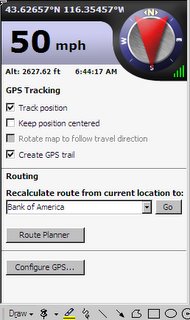
We bought DeLorme Street Atlas with GPS with the idea of using it to guide us through our travels this summer. After trying to use it a couple of times on short trips in Arizona I decided that it wasn't as good as Microsoft's Streets and Trips. After learning that I could use the DeLorme GPS unit with S&T by loading DeLorme Serial Emulator program, I tried it. It works well.

 I have been planning our daily travels a couple of days in advance and adding them to the trip planner in S&T. I delete the places we have been and use our current location as the starting point. I put the Delorme GPS unit (I call it the hockey puck) on the RV or car dashboard. Once I get S&T up and running I bring up the GPS task pane and perform a scan (click on Configure GPS button) to locate the puck. I then click on the Track position box and Create GPS Trail box. The little car in a circle appears at our current location. Once we start to move the car moves along our route.
 When moving around a strange city the GPS really helped to make sure we were on track.


No comments:
Post a Comment